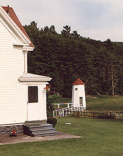
Kennebec River Front Range Light
From lighthouses
(New page: ''Kennebec River Front Range Light'' in 1986 Arrowsic, Maine Built: 1898 Automated: 1979 Formerly called the Doubling Point Ra...) |
m |
||
| Line 17: | Line 17: | ||
[[Category:Lighthouse]] | [[Category:Lighthouse]] | ||
| - | [[Category:Atlantic | + | [[Category:Atlantic]] |
[[Category:Kennebec River]] | [[Category:Kennebec River]] | ||
| - | |||
[[Category:Maine]] | [[Category:Maine]] | ||
Revision as of 18:15, 12 May 2009
Arrowsic, Maine
Built: 1898
Automated: 1979
Formerly called the Doubling Point Range Light, this octagonal wooden structure sits 235 yards from an identically shaped rear light along the Kennebec River on Arrowsic Island. It is one of four lights located along the river that guided ships from the Atlantic Ocean to the shipbuilding town of Bath, Maine. (The others are Doubling Point Light, Perkins Island Light, and Squirrel Point Light.) Originally equipped with a fifth-order Fresnel lens, it currently houses a 250 mm modern lens which was installed in 1979 when the light was automated. A photo showing both Kennebec River Range Lights, as well as photos of Perkins Island and Squirrel Point lights can be seen by going to the Fortieth Lighthouse Expedition.
Navigational Options
- Return to The Maiden Journey
- Go to Alphabetical Listing
- Go to Geographical Listing
- Return to Lighthouse Home Page
Lighthouses: A Photographic Journey
- Conceived and Developed by David S. Carter
- Photographs by Donald W. Carter
- Text by Diana K. Carter, Donald W. Carter & David S. Carter
Copyright © 1995-2011 David S. Carter, Donald W. Carter, & Diana K. Carter. All rights reserved. Reproduction by any means, physical or electronic, in part or in full, without the express permission of the authors, is strictly prohibited.
This article was last modified on 5/12/2009.

