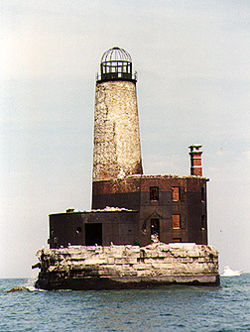
Waugoshance Shoal Light
From lighthouses
(Difference between revisions)
m (Waugoshance Light moved to Waugoshance Shoal Light) |
|||
| (2 intermediate revisions not shown.) | |||
| Line 1: | Line 1: | ||
| - | [[Image:Waugoshance Light.jpg|thumb|250px|''Waugoshance Light'' in 1988]] | + | [[Image:Waugoshance Shoal Light.jpg|thumb|250px|''Waugoshance Shoal Light'' in 1988 - 4th trip]] |
NW of Waugoshance Island, Michigan | NW of Waugoshance Island, Michigan | ||
| Line 23: | Line 23: | ||
[[Category:Great Lakes]] | [[Category:Great Lakes]] | ||
[[Category:Lake Michigan]] | [[Category:Lake Michigan]] | ||
| - | |||
[[Category:Michigan]] | [[Category:Michigan]] | ||
Current revision
NW of Waugoshance Island, Michigan
Built: 1851
Decommissioned: 1912
Even though it was once used for target practice during World War II, this decaying structure still stands, barely, at the place where it once warned ships of the dangerous formation near the Straits of Mackinac where the water depth can get to less than twelve feet.
Navigational Options
- Return to Second Lighthouse Expedition
- Return to Fourth Lighthouse Expedition
- Return to Fifth Lighthouse Expedition
- Return to Thirty-eighth Lighthouse Expedition
- Return to Forty-sixth Lighthouse Expedition
- Go to Alphabetical Listing
- Go to Geographical Listing
- Return to Lighthouse Home Page
Lighthouses: A Photographic Journey
- Conceived and Developed by David S. Carter
- Photographs by Donald W. Carter
- Text by Diana K. Carter, Donald W. Carter & David S. Carter
Copyright © 1995-2011 David S. Carter, Donald W. Carter, & Diana K. Carter. All rights reserved. Reproduction by any means, physical or electronic, in part or in full, without the express permission of the authors, is strictly prohibited.
This article was last modified on 6/3/2009.

